Iran Mountain
By: Homayoon Bakhtyari

Due to its historical background and sustained social and cultural evolution Iran has a lot of diverse sightseeing satisfying all kinds of tourists with different tastes. Every tourist, whatever his incentive, may find many spectacular places based on his interest. It should not be forgotten that direct contact is the best way for the appreciation of a country and its people..
Remains of historical monuments belonging to different periods of human settlement on the Iranian plateau together with a diverse nature, coastal, mountainous and nomadic landscapes make a coordinated attraction for every tourist.
The mountains and mountain slopes in Iran with their economic value for nomads provide also summer residence for urban dwellers as well as good places for winter and summer mountain sports. The desert region of Iran has its own touristic attractions. These regions were the passing places of merchant caravans between east and west of Iran and therefore encompass the remains of hundreds of old Caravansaries and water reservoirs. The desert landscape with running sands, stone plains, salty lands and rivers scattered with large and small oases form a totally dry but very attractive nature.
Iran with hundreds of mountains above 4000 meters is a good place for those who are interested in mountaineering or trekking. Damavand (5671 meters) is the highest point of Iran and every year thousands of Iranian and foreign climbers are climbing it in different seasons. I. R. Iran Mountaineering Federation is going to build one of world's highest shelters at 4000 meters on this mountain to provide appropriate facilities for climbers.
When you choose one of the many trekking paths in Iran you can not only enjoy trekking but also have the opportunity to visit local people on their homelands and have close contact with Iranian customs and culture.

The ancient Iranian culture reflected in its historical and architectural heritage, has brought about many places worth of visiting. The culture of today's Iran is a perfect synthesis of near and far past of this territory and every visitor can satisfy his intellectual and aesthetic needs according to his own taste by travelling this wide and rich country. The historical monuments of Persepolis, Pasargad, Susa, Hamadan, Kermanshah, Kerman and many other ancient places are incentive enough for visiting Iran.
Mountaineering in Iran
Since Iran is a mountainous country, mountains and mountaineering are naturally related to Iranian life. Mountaineering as a sport and outdoor activity seriously started in Iran about 60 years ago and specially people who were working in the military went to the mountains to practice sport and exploration of remote areas. The first group of Iranians who attended technical climbing courses were also soldiers, but after a few years they were joined by civilians and nowadays you can see thousands of Iranian who are involved in it.
The first expeditions to go to the Himalayas were again from the army; they sent a few groups to the Himalayas for some reconnaissance but they did not do any serious climbs till 1975 when a joint Iranian and Japanese expedition climbed Manaslu. After Islamic revolution and because of invasion of Iraq to Iran and the following war no proper climbs were possible in the Himalayas; most of mountaineering focused on winter ascents inside Iran and on the big walls and mountains mostly above 4500 m.
In 1994 the I. R. Iran Mountaineering Federation, the main body of mountaineering and hill walking in Iran, organized a 5-year program to climb Mt.Everest. The first expedition was sent to climb peak Peak Communism, the highest peak in the Pamir range in Tajikistan and they succeeded in putting four climbers on the top. The following year another group went to Kazakhstan to climb Khan Tengri 7010 m and seven members reached the summit. 1997 was a busy year, two expeditions were sent to Pakistan and they climbed Gasherbum II (8035 m) and Rakaposhi (7788 m). In spring 1998 the first Iranian Everest expedition left Iran for Nepal and after almost three months four Iranians stood on the top of the world; this expedition was considered the strongest expedition on Everest in that year.
First Youth expedition climbed Peak Pobeda in 1999 and in year 2000 one Iranian Iranian expedition climbed Mt.Cho-Oyu and Shishapangma which are among 8000 meters peak one after another in Spring. In Spring 2001 Iranian Mountaineering National team went to Himalayas again and could successfully climbed Mt.Makalu the 5th highest peak of the world and 7 climbers among this 16 members expedition made the summit.
Beside all the above activities and expeditions people do mountaineering and climbing all over Iran, these climbs staged from very simple routes and trekking to very technical winter or summer ascents on the technical mountains such as Damavand 5671 m or Alam-Kouh 4850 m which has a 750 m vertical granite face.Mt. Damavand 5671 m.
Damavand peak
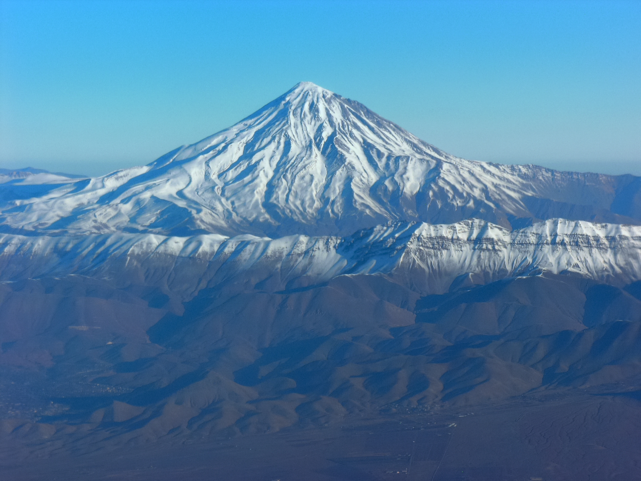
Many global tourists and alpinists consider Damavand the most beautiful conical and unique peak of Asia and the highest peak of Iran. Fly 5 hours from the farthest part of Europe to Tehran. Drive 75 km by car to the North of the Alborz chain through plains of flowers and green slopes of Damavand. It is an 8-hour trek and an 8-hour climb to the glorious peak of Damavand.
Mt. Damavand with 5671 meters lies only 100 km from Tehran and 75 km to Caspian sea. There have been many myths written about this mountain in Iranian history and it can be called a legend mountain. It is said that there is a monster banned on the summit.
The slopes and skirts of this mount are filled with volcanic lava. Moreover, there are a number of small volcanic mouths near the peak from which sulfur gases usually flow out.
Damavand has several glaciers, the most important of them are Dobisel and Sioleeh glaciers in the north, Yakhar glacier in the east.
It has four main routes and each has a different character. South route is the normal route which has one refuge at 4100 m. North has two refuges whith the first one at 4000 m and second at 5000 m. West route has one refuge at 4550 m and the North East route has one refuge at 4800 m. The summit is covered with yellowish sulfuric rocks and the diameter of the crater is about 180 meters. Albourz Range of which Mt. Damavand is the highest peak is a chain along the range of Alps and Himalayas, but Damavand is not connected to any other mountains of Albourz range. It is estimated that this volcano is 2 billion years old. Because of its particular location with the Caspian Sea on the North and desert on the South it has a particular climate and wild life. Winds generally blow from west and northwest which contains humidity and rain. Because of species and vegetation you can see nomads who are living on its base during late spring and summer.
The first successful recorded climb to this peak goes back to 1900. During that year, some Iranian geographers, affiliated to Mozaffari Geographic Mission, succeeded to reach the top through a very difficult glacier course, called Yakhar Valley. From that time to 1936, there is no recorded climb. But in the 1940s, the climbs were multiplied and new routes were opened. Damavand is the national symbol of Iran and there are many organizations getting benefit from the picture of this famous peak; you can find it for instance on bank notes, credit cards or bus tickets.
During the last 50 years many foreigners have been attracted to climb Damavand peak.
Although Damavand had no eruption since 100,000 years ago and been inactive, the geologists have not denied it might be activated again and offered a few reasons for their points of view. One of the evidences that this Volcano is still active is hot mineral water springs all over it. This mineral water spa attracted people who believe in getting cured by soaking in it.
This peak is situated above the village of Bisotun, about 30 km east along the road from Kermanshah to Hamadan. At the eastern end of the cliff are carvings from the period of Darius the Great from 2,500 years ago. The peak is very close to another peak named Paru where the famous Ghare Parau cave is situated.
The South-East face is lime stone rock and about 1000 meters high, there are many different routes which were opened by Iranian and foreign climbers during the last 30-40 years. These routes are from at least 4 pitches to 15 pitches with different type of difficulty. It takes at least 5 hours to climb one of the routes on this wall. The best way to come down the face is to abseil but you can easily follow a trek from North side down to the Bisotun village.
Since this mountain is very close to Kermanshah climbers can easily fly to Kermanshah and then in less than 20 minutes they can start a very good climb. The best seasons to climb on Bisotun are from late March to June and from early September to early November.
Geology - The Alborz range is considered to belong to the Tertiary geological Orogeny. During the last few years many Iranian and foreign geologists have studied and surveyed the Alborz ranges in detail and geologists prepared a geological map of Iran it shows that Alam Kouh is mainly made of tertiary intrusive rocks; granite and diorite. Some Triassic and Jurassic sediments are also found.History - The Takht-e-Soleiman region was unknown until 1933. Douglas Busk, a British mountaineer, discovered and surveyed the area. Later on, Busk along with Professor Bobek made a detailed survey of this area. In 1936 the north ridge of Alam Kouh was climbed for the first time by German mountaineers, which was considered a great achievement among European climbers.
The most important peaks of Thakht-e-Soleiman and Alam Kouh region by ranking of altitude are:
Alam Kouh (4850 m), the second highest peak in Iran. Its northern face is one of the highest and challenging faces in Iran. Alam Kouh has four glaciers around its peak.
Takht-e-Soleiman (4659 m), located between Seyahsang and Shaneh Kouh, with two glaciers on its southern side. This peak was first climbed in 1936 by German mountaineers.
Alamkooh wall

There are more than ten other peaks over 4000 m in the region and many glaciers which have first been studied by the mentioned Douglas Busk in 1933 and Dr. Hans Bobek, who was Professor of Geography in Berlin and Vienna Universities and surveyed and mapped the glacier in 1934.
Wild Life of Takht-e-Soleiman is interesting, bears and leopards have been observed in this area. Mountain ibex, mountain ram and similar animals are abundant in the green lands around Rostam and Nesht peak.
Sabalan peak

Saballan is third highest peak of Iran, located on the North West of Iran near the city of Ardabil. This beautiful mountain which is a volcano like Damavand is very popular for climbing in spring and summer time because of its landscape. While you go to climb it you get the opportunity to visit Shahsavan nomads who pass their summer time on the foot of this mountain.
The summit is very nice and there is lake on the top which is frozen until mid-summer. It can be said that after Mt. Damavand, Mt. Saballan is the most popular mountain among Iranian climbers.
Zagrous mountain

In the Zagrous mountain ranges and the southern part of Oshtoran Kooh mountain chain and near the phantastic and snowy peak of Keynou, there is a vast lake known as "Shat-e-Temi" (Shat in Arabic means lake) at an altitude of 2000 m; the water of this lake is obtained from melting snow of Mt. Keynou. A part of Temi Lake is seasonal and is formed only in rainy seasons; the other part is permanent because of the gradual melting of Mt. Keynou's glaciers in the warm season. The length of seasonal part of the lake is about 150 ha, while the permanent part has approximately 40 ha. These two lakes are connected to each other through a strait, which is formed by two hills; the width of this strait is approximately 200 m.
The lakes have no feeder and no outlet rivers. Moreover, in its water one cannot find any kind of fish or marine organism.
The type of the mountains of this region is limestone, the mountains are young and their summits are sharp. On the itinerary of Temi program the clients will pass through villages on their way, they will also meet the nomads of this region and visit their tents. Crypts engraved in the heart of mountains will be found in caves, these crypts date back to the 6th century BC (the Medes dynasty). This trip is one of the most fascinating programs of its kind and its visitors will find it highly attractive.
This region is considered to be a very suitable place for the nomad's migration especially when they start their major migration from the warmer part of Khuzestan plain toward cooler part of Mts. Oshtorjan Kooh and Zard Kooh. The best time for having a delightful trek in this region is from the beginning of April to May.
هیچ نظری موجود نیست:
ارسال یک نظر